Which housing structures prevail where? The "Cockpit" provides valuable data on this.
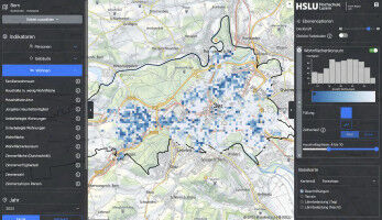
Where in the settlement area do more children of pre-school age live? Where and how do older households live?The "Cockpit Public Planning" provides high-resolution spatial data visualizations for these and many other questions. This form of data preparation is not only informative, but also provides particularly low-threshold access to statistical data.
The ’Cockpit Public Planning’ offers municipalities a handy information basis for dealing with social policy issues in line with requirements. The ’Cockpit’ helps, for example, to bring integration and prevention projects closer to the stakeholder groups. This increases their effectiveness. The ’Cockpit’ supports the municipalities in designing and using public spaces in accordance with the local population composition. This increases the quality of life of the population and the residential attractiveness of the municipality. The ’Cockpit’ also helps with the needs-based planning of population-oriented services such as daycare centers or Spitex: In which neighborhood could there be an increased need for a daycare center? Where should the Spitex bases be located so that travel times to patients are as short as possible? The ’Cockpit’ can also provide valuable answers to such questions.
The ’Cockpit Public Planning’ supports municipalities in dealing with housing policy issues. For this purpose, the tool has various indicators on the housing structure and the housing conditions of the population. For the latter, the ’Cockpit’ provides, among other things, visualizations of per capita living space or overcrowded and undercrowded apartments. The ’Cockpit’ thus helps, for example, to assess the housing situation in old age or the housing situation of family households and to plan fact-based measures.
Affordable housing is also a pressing issue in many places. There are many factors that affect the price of housing, such as building age, building size, residential location or floor space. Building characteristics are displayed in the ’Cockpit’ on a building-by-building basis. The residential location can be read directly from the stored geographical map. With the average room area, the ’Cockpit’ has a particularly relevant indicator with regard to affordable housing: among other things, it can be used to show that buildings in the 1950s and 1960s were significantly smaller than those of today, although there are differences depending on the residential location. In addition to the age of the buildings, this also contributes to the lower housing costs. The local population composition provides further indications of where affordable housing is actually still available.
The ’Cockpit Public Planning’ is also a planning and monitoring tool for municipal, urban and neighborhood development that also allows a look into the past. The data available in this tool goes back to 2012. This allows various developments in the settlement area to be identified. It is also helpful in this respect that the ’Cockpit’ has different scales. The canton-wide municipal overview makes it possible to draw municipal and regional comparisons. Within the municipality, a district evaluation is available as well as - as the most detailed resolution - hectare tiles with an edge length of 100 meters.
The Lucerne University of Applied Sciences and Arts offers municipalities and other public institutions nationwide online access to the ’Cockpit Public Planning’ for an annual license fee. In this way, the HSLU is supplementing its existing extensive range of consulting services in the public sector and hopes to make an additional contribution to the quality and efficiency of public planning processes. A non-binding offer for the ’Cockpit Public Planning’ can be requested via our website.